
-
Trouble logging in? Send us a message with your username and/or email address for help.
-
Hello all! We will be performing a website & forum update soon. You may get logged out so now is the time to make sure your email address in your account is correct - go to your account to check it and update it now. Send us a message with your username and/or email address if you need help.
You are using an out of date browser. It may not display this or other websites correctly.
You should upgrade or use an alternative browser.
You should upgrade or use an alternative browser.
Hurricane Dorian
- Thread starter Kurt
- Start date
New posts


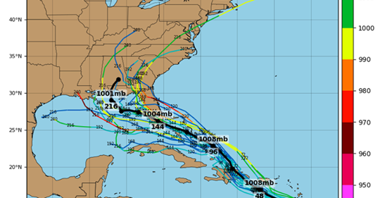 Now this is a graphic!


remember the tough guy with all the "I'm not going anywhere" last year?
New posts


Kurt
Admin
Hurricane Safety Tips and Resources
Hurricanes are among nature's most powerful and destructive phenomena. On average, 12 tropical storms, 6 of which become hurricanes form over the Atlantic Ocean, Caribbean Sea, or Gulf of Mexico during the hurricane season which runs from June 1 to November 30 each year. In the Central Pacific Ocean, an average of 3 tropical storms, 2 of which become hurricanes form or move over the area during the hurricane season, which runs from June 1 to November 30 each year. Guam, the Northern Marianas and Micronesia experience typhoons all year round but the main season in July through November with a peak from mid-August to mid-September. Over a typical 2-year period, the U.S. coastline is struck by an average of 3 hurricanes, 1 of which is classified as a major hurricane (winds of 111 mph or greater). By knowing what actions to take before the hurricane season begins, when a hurricane approaches, and when the storm is in your area, as well as what to do after a hurricane leaves your area, you can increase your chance of survival. If you, or someone you know, have been a victim of a hurricane, please share your story, including the town and state you were in and the year the event took place.. Please note that NS will then have permission to use your story for educational campaigns. Sharing this information may help save someone’s life in the future. Read stories from survivors and learn how to stay safe.
Hurricane Hazards
While hurricanes pose the greatest threat to life and property, tropical storms and depression also can be devastating. The primary hazards from tropical cyclones (which include tropical depressions, tropical storms, and hurricanes) are storm surge flooding, inland flooding from heavy rains, destructive winds, tornadoes, and high surf and rip currents.
Hurricanes are among nature's most powerful and destructive phenomena. On average, 12 tropical storms, 6 of which become hurricanes form over the Atlantic Ocean, Caribbean Sea, or Gulf of Mexico during the hurricane season which runs from June 1 to November 30 each year. In the Central Pacific Ocean, an average of 3 tropical storms, 2 of which become hurricanes form or move over the area during the hurricane season, which runs from June 1 to November 30 each year. Guam, the Northern Marianas and Micronesia experience typhoons all year round but the main season in July through November with a peak from mid-August to mid-September. Over a typical 2-year period, the U.S. coastline is struck by an average of 3 hurricanes, 1 of which is classified as a major hurricane (winds of 111 mph or greater). By knowing what actions to take before the hurricane season begins, when a hurricane approaches, and when the storm is in your area, as well as what to do after a hurricane leaves your area, you can increase your chance of survival. If you, or someone you know, have been a victim of a hurricane, please share your story, including the town and state you were in and the year the event took place.. Please note that NS will then have permission to use your story for educational campaigns. Sharing this information may help save someone’s life in the future. Read stories from survivors and learn how to stay safe.
Hurricane Hazards
While hurricanes pose the greatest threat to life and property, tropical storms and depression also can be devastating. The primary hazards from tropical cyclones (which include tropical depressions, tropical storms, and hurricanes) are storm surge flooding, inland flooding from heavy rains, destructive winds, tornadoes, and high surf and rip currents.
- Storm surge is the abnormal rise of water generated by a storm's winds. This hazard is historically the leading cause of hurricane related deaths in the United States. Storm surge and large battering waves can result in large loss of life and cause massive destruction along the coast.
- Storm surge can travel several miles inland, especially along bays, rivers, and estuaries.
- Flooding from heavy rains is the second leading cause of fatalities from landfalling tropical cyclones. Widespread torrential rains associated with these storms often cause flooding hundreds of miles inland. This flooding can persist for several days after a storm has dissipated.
- Winds from a hurricane can destroy buildings and manufactured homes. Signs, roofing material, and other items left outside can become flying missiles during hurricanes.
- Tornadoes can accompany landfalling tropical cyclones. These tornadoes typically occur in rain bands well away from the center of the storm.
- Dangerous waves produced by a tropical cyclone's strong winds can pose a significant hazard to coastal residents and mariners. These waves can cause deadly rip currents, significant beach erosion, and damage to structures along the coastline, even when the storm is more than a 1,000 miles offshore.
James Bentwood
Beach Fanatic
As Puerto Rico Braces For Storm, DHS, FEMA To Move $271 Million To Border Operations
As Puerto Rico Braces For Storm, DHS, FEMA To Move $271 Million To Border Operations
As a major storm heads for Puerto Rico, the Department of Homeland Security and its Federal Emergency Management Agency said Tuesday they will move $271 million in funds to support President Trump's border enforcement efforts.
The Department of Homeland Security said it will transfer the emergency funds — including $155 million from FEMA's disaster relief fund — to support new Immigration and Customs Enforcement detention beds as well as facilities for related court cases, according to documents obtained by NPR.
In a July notification to Congress about the transfer, DHS said the $155 million comes from recoveries of prior year funds and that "absent significant new catastrophic events" the department believes the fund will still have enough money to operate.
Congressional Democrats slammed the move on Tuesday, which comes at the peak of hurricane season and as Tropical Storm Dorian was poised to reach hurricane levels.
"The Trump administration's plan to divert money away from FEMA at the start of hurricane season to continue its efforts to separate and jail migrant families is backwards and cruel," Senate Minority Leader Chuck Schumer, D-N.Y., said. "Taking these critical funds from disaster preparedness and recovery efforts threatens lives and weakens the government's ability to help Americans in the wake of natural disasters. Congress appropriated these funds to meet the American peoples' priorities and I strongly oppose this effort to undermine our constitutional authority."
DHS alerted Congress to the move in a 15-page notification dated July 26, which NBC first reported earlier Tuesday. The agency is required to give Congress a 30-day notice to the plans.
Democrats, opposed to the move, waited to respond until the end of that notification period in hopes of delaying the costly action, a congressional source familiar with the plans said.
"I have significant concerns about the intended use of funds, and consequently, about the tradeoffs between that use and activities that would otherwise be funded from the source accounts," California Rep. Lucille Roybal-Allard, chair of a House Appropriations subcommittee, told DHS Secretary Kevin McAleenan in an Aug. 23 letter.
As Puerto Rico Braces For Storm, DHS, FEMA To Move $271 Million To Border Operations
As a major storm heads for Puerto Rico, the Department of Homeland Security and its Federal Emergency Management Agency said Tuesday they will move $271 million in funds to support President Trump's border enforcement efforts.
The Department of Homeland Security said it will transfer the emergency funds — including $155 million from FEMA's disaster relief fund — to support new Immigration and Customs Enforcement detention beds as well as facilities for related court cases, according to documents obtained by NPR.
In a July notification to Congress about the transfer, DHS said the $155 million comes from recoveries of prior year funds and that "absent significant new catastrophic events" the department believes the fund will still have enough money to operate.
Congressional Democrats slammed the move on Tuesday, which comes at the peak of hurricane season and as Tropical Storm Dorian was poised to reach hurricane levels.
"The Trump administration's plan to divert money away from FEMA at the start of hurricane season to continue its efforts to separate and jail migrant families is backwards and cruel," Senate Minority Leader Chuck Schumer, D-N.Y., said. "Taking these critical funds from disaster preparedness and recovery efforts threatens lives and weakens the government's ability to help Americans in the wake of natural disasters. Congress appropriated these funds to meet the American peoples' priorities and I strongly oppose this effort to undermine our constitutional authority."
DHS alerted Congress to the move in a 15-page notification dated July 26, which NBC first reported earlier Tuesday. The agency is required to give Congress a 30-day notice to the plans.
Democrats, opposed to the move, waited to respond until the end of that notification period in hopes of delaying the costly action, a congressional source familiar with the plans said.
"I have significant concerns about the intended use of funds, and consequently, about the tradeoffs between that use and activities that would otherwise be funded from the source accounts," California Rep. Lucille Roybal-Allard, chair of a House Appropriations subcommittee, told DHS Secretary Kevin McAleenan in an Aug. 23 letter.
South Walton Fire District
5AM Wed- Tropical Storm Dorian Update
There is still a high degree of uncertainty regarding the latest track forecast for Tropical Storm Dorian.
Currently the biggest threat locally is heavy rain but we ask that you continue to track and monitor this storm.
Ensuring your hurricane supplies/kit are ready and that you and your family have a plan is the most important thing you can do right now.
Please remain weather aware and only receive your weather information from trusted reliable media sources such as:
South Walton Fire District
Walton County Emergency Management
National Weather Service in Tallahassee
WJHG-TV WMBB-TV
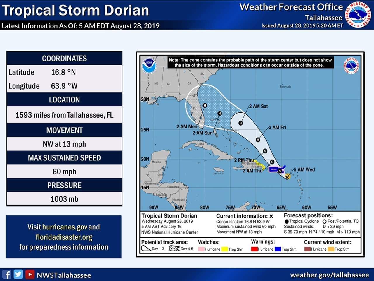
5AM Wed- Tropical Storm Dorian Update
There is still a high degree of uncertainty regarding the latest track forecast for Tropical Storm Dorian.
Currently the biggest threat locally is heavy rain but we ask that you continue to track and monitor this storm.
Ensuring your hurricane supplies/kit are ready and that you and your family have a plan is the most important thing you can do right now.
Please remain weather aware and only receive your weather information from trusted reliable media sources such as:
South Walton Fire District
Walton County Emergency Management
National Weather Service in Tallahassee
WJHG-TV WMBB-TV
Cat 4 Hurricane predicted
Walton County Emergency Management
Facebook Post Thursday August 29
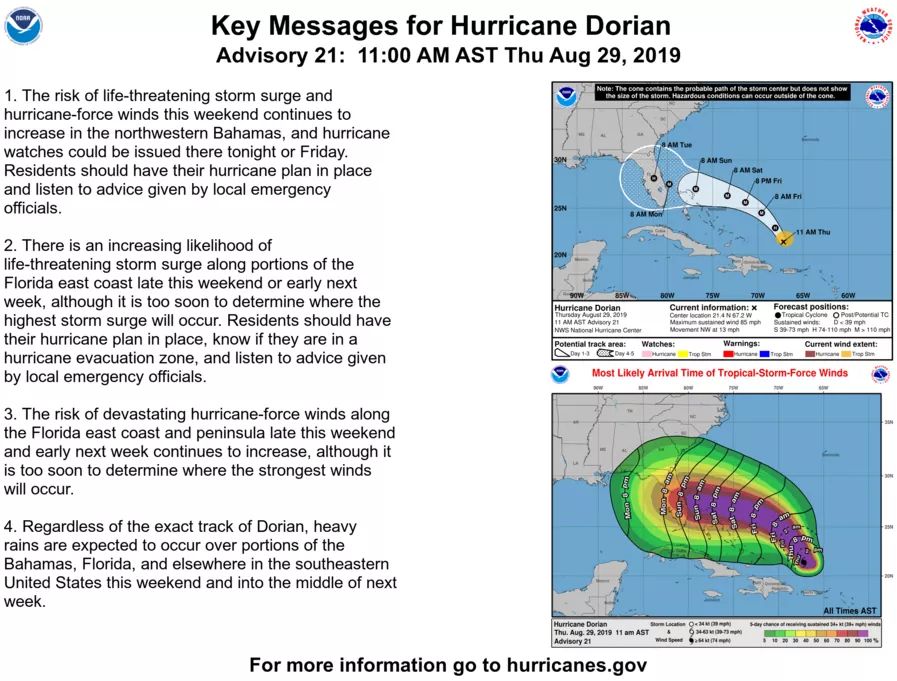
Hurricane Dorain is now being forecast to be a Category 4 Major Hurricane off the Florida Coast Sunday into Monday. The exact track is unknown after Day 4. However, a slower movement is expected near landfall as it moves near and over Florida. A slower movement will increase the heavy rainfall and flash flood/river flood threat.
We encourage you to not get caught up in models and speculation from non National Weather Service Offices. These are only snapshots which have, can, and will continue to change at almost every run. Only trained meteorologists can interpret these and translate them to actual impacts.
We want to continue to stress that you, your families, and businesses should ALWAYS have hurricane plans. Register for AlertWalton at www.alertwalton.org. Build a Kit. Make a Plan. Be Informed.
Walton County Emergency Management
Facebook Post Thursday August 29
Hurricane Dorain is now being forecast to be a Category 4 Major Hurricane off the Florida Coast Sunday into Monday. The exact track is unknown after Day 4. However, a slower movement is expected near landfall as it moves near and over Florida. A slower movement will increase the heavy rainfall and flash flood/river flood threat.
We encourage you to not get caught up in models and speculation from non National Weather Service Offices. These are only snapshots which have, can, and will continue to change at almost every run. Only trained meteorologists can interpret these and translate them to actual impacts.
We want to continue to stress that you, your families, and businesses should ALWAYS have hurricane plans. Register for AlertWalton at www.alertwalton.org. Build a Kit. Make a Plan. Be Informed.
Lake View Too
SoWal Insider
Emerald Drifter
Beach Fanatic
A few helpful links:
- Miami Herald has taken down their normal paywall and will be free to view until Dorian is over: www.miamiherald.com
- Mike's Weather Page: Mike is out of Tampa Bay area, is a weather hobbiest/nerd and has lots of links to NHC, NOAA and also has an informative Facebook page: www.spaghettimodels.com. Of course, for the most conclusive ACTIONABLE information, go to www.nhc.noaa.gov.
- Live Storms Media YouTube channel: I don't know how they do it but they are always in the eye of the storm. Their video coverage of Michael was amazing. Live Storms Media This one video account from Michael is riveting and if you are an animal lover, you will see that Hal Summers is a hero:
raven316
Beach Lover
A few helpful links:
- Miami Herald has taken down their normal paywall and will be free to view until Dorian is over: www.miamiherald.com
- Mike's Weather Page: Mike is out of Tampa Bay area, is a weather hobbiest/nerd and has lots of links to NHC, NOAA and also has an informative Facebook page: www.spaghettimodels.com. Of course, for the most conclusive ACTIONABLE information, go to www.nhc.noaa.gov.
- Live Storms Media YouTube channel: I don't know how they do it but they are always in the eye of the storm. Their video coverage of Michael was amazing. Live Storms Media This one video account from Michael is riveting and if you are an animal lover, you will see that Hal Summers is a hero:
remember the tough guy with all the "I'm not going anywhere" last year?