
-
Trouble logging in? Send us a message with your username and/or email address for help.
-
Hello all! We will be performing a website & forum update soon. You may get logged out so now is the time to make sure your email address in your account is correct - go to your account to check it and update it now. Send us a message with your username and/or email address if you need help.
You are using an out of date browser. It may not display this or other websites correctly.
You should upgrade or use an alternative browser.
You should upgrade or use an alternative browser.
Historic SoWal trivia
- Thread starter Sun Chaser
- Start date
New posts


Oh that sounds awesome. Jpg will work but need to resize for smaller file size. Kurt?

Most of the free email hosts will accept up to 20MB attachments. You may be able to email it to webmaster@sowal.com and they can post it.
If you have Dropbox, Box, or any other online storage, you can upload the file, the right click the uploaded file, click "copy Dropbox link", then, finally click the "Link" icon (7th from the left above your message reply box) and paste the copied Dropbox link.
New posts
Lake View Too
SoWal Insider
I vaguely remember one of those "flying saucer" kind of houses on the south west landing of the old bridge (late 50's ?) where "Baily's", and "Blue Bar", and "Barago's" has been. What was that building before it was "Baily's By the Bay"?
Will B
Moderator
It was hit on more than one occasion and actually killed the bridge master in one of the collisions.331 was a draw bridge when I first moved here. Until a barge hit it.
jodiFL
Beach Fanatic
I think it was the residence of the Baileys. I still see and talk to the owner of "Baileys by the Bay" so I will ask her the next time I run into her and let you know.I vaguely remember one of those "flying saucer" kind of houses on the south west landing of the old bridge (late 50's ?) where "Baily's", and "Blue Bar", and "Barago's" has been. What was that building before it was "Baily's By the Bay"?
Lake View Too
SoWal Insider
To be honest, I'm drawing a total blank on the name of the owner of "Bailey's", although I have met her once, but she lived next door. "Bailey's" was something else before that... come on guys, we still have brain cells, right?...
Garrett Horn
Beach Lover
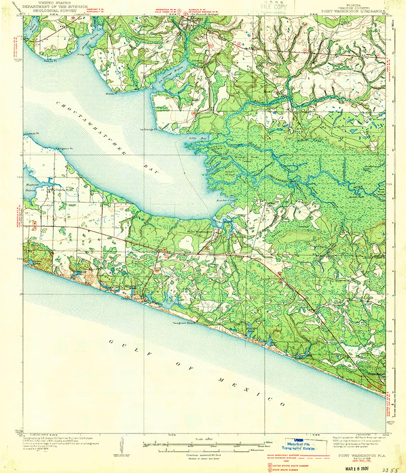
I have a great map of this area, including Freeport, Pt. Washington, Grayton, Seagrove, etc. It's dated 1939, and there is no bridge across the bay. I have it in PDF (7.5MB) and JPG (16.7 MB) but I can't get either one to post on here. I'd love to share this map, so somebody give me clue how to convert it.
I have a great map of this area, including Freeport, Pt. Washington, Grayton, Seagrove, etc. It's dated 1939, and there is no bridge across the bay. I have it in PDF (7.5MB) and JPG (16.7 MB) but I can't get either one to post on here. I'd love to share this map, so somebody give me clue how to convert it.
Oh that sounds awesome. Jpg will work but need to resize for smaller file size. Kurt?
Emerald Drifter
Beach Fanatic
I have a great map of this area, including Freeport, Pt. Washington, Grayton, Seagrove, etc. It's dated 1939, and there is no bridge across the bay. I have it in PDF (7.5MB) and JPG (16.7 MB) but I can't get either one to post on here. I'd love to share this map, so somebody give me clue how to convert it.
Most of the free email hosts will accept up to 20MB attachments. You may be able to email it to webmaster@sowal.com and they can post it.
If you have Dropbox, Box, or any other online storage, you can upload the file, the right click the uploaded file, click "copy Dropbox link", then, finally click the "Link" icon (7th from the left above your message reply box) and paste the copied Dropbox link.
Garrett Horn
Beach Lover
Last edited by a moderator: