• Trouble logging in? Send us a message with your username and/or email address for help.
  • Hello all! We will be performing a website & forum update soon. You may get logged out so now is the time to make sure your email address in your account is correct - go to your account to check it and update it now. Send us a message with your username and/or email address if you need help.

Hurricane Helene Updates & Info

New posts

Kurt

Admin
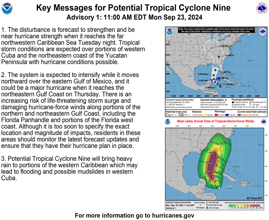
As of now the storm is forecast to pass to the the east of us in the Big Bend area of Florida, and come ashore as a major hurricane. It's still a couple of days from making landfall, so it's too early to tell the effects on SoWal.


153941_key_messages_sm.png


094028_5day_cone_no_line_and_wind.png
 
Last edited:

National Hurricane Center​

Text products​

Productos de texto (en español)​

Graphical products​

Servicio Meteorológico Nacional (Mexico)​

Instituto de Meteorología (Cuba)​

National Weather Service (Cayman Islands)​

National Hurricane Center (United States)​

Weather Forecast Offices​

Forecast discussions​

Aircraft reconnaissance​


National Hurricane Center​

Radar imagery​


Radar mosaics​

Servicio Meteorológico Nacional (Mexico)​

Single-site radar imagery​

Instituto de Meteorología (Cuba)​

Satellite imagery​


Storm-specific imagery​

Regional imagery​

NOAA GOES Image Viewer​

Cooperative Institute for Meteorological Satellite Studies (CMISS)​

Tropical Tidbits​

Weather Nerds​

Analysis graphics and data​


Wind analyses​

Sea-surface Temperatures​

Model guidance​


Storm-specific guidance​

Regional single-model guidance​

  • Tropical Tidbits: GFS
  • Tropical Tidbits: ECMWF
  • Tropical Tidbits: CMC
  • Tropical Tidbits: ICON

Regional ensemble model guidance​

 
Every year the forecasts get more dire, the coverage starts earlier, the headline font bigger and bolder, and that cone hundreds of miles wider. Gotta love the media. Pray for Georgia too as the entire state is in the path of the eye.
 
Every year the forecasts get more dire, the coverage starts earlier, the headline font bigger and bolder, and that cone hundreds of miles wider. Gotta love the media. Pray for Georgia too as the entire state is in the path of the eye.
We're you around for Michael? There is a reason for the increased awareness. When Helene gets in the Gulf, things may start occurring very quickly.
 
The National Hurricane Center has upgraded Potential Tropical Cyclone Nine to Tropical Storm Helene. Helene is forecast to strengthen into a hurricane by Wednesday morning as it slips between Mexico's Yucatán Peninsula and western Cuba and enters the Gulf of Mexico. Helene is forecast to strengthen into a major hurricane as it approaches Florida's Big Bend region later in the week.

Thread title updated.
 
We're you around for Michael? There is a reason for the increased awareness. When Helene gets in the Gulf, things may start occurring very quickly.
October 10, 2018, a Wednesday afternoon as I recall. I was in Freeport, Windswept Dunes. We got off easy compared to just a short drive east of us. Never seen anything like it, and I grew up in Biloxi.

This short recount of Hal Summers in Mexico Beach, always stuck with me.

Full playlist of other accounts and footage of Michael for the weather geeks among us. :)
 
New posts


Sign Up for SoWal Newsletter


Back
Top