
-
Trouble logging in? Send us a message with your username and/or email address for help.
-
Hello all! We will be performing a website & forum update soon. You may get logged out so now is the time to make sure your email address in your account is correct - go to your account to check it and update it now. Send us a message with your username and/or email address if you need help.
You are using an out of date browser. It may not display this or other websites correctly.
You should upgrade or use an alternative browser.
You should upgrade or use an alternative browser.
land purchase
- Thread starter dunebug
- Start date
New posts


FEMA shows the entire area as a flood zone, right up to the back of Seacrest. Not sure how anyone could "make a mistake" and buy something like that without knowing.
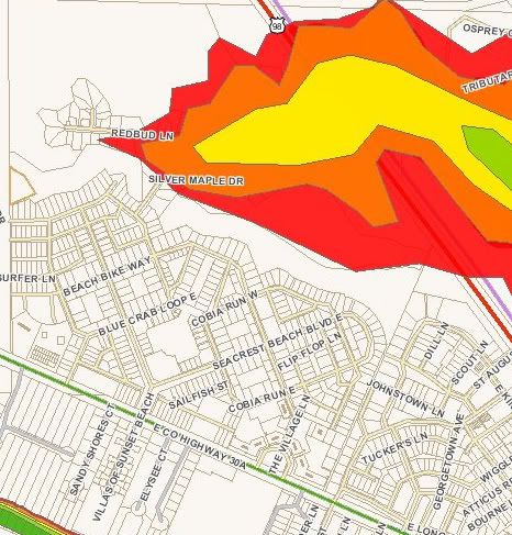
Seacrest is in good shape - from 30 to 35 feet, Treetop ranges from 12 to about 20 depending on the location.

I think you mistakenly think that this "Storm Surge" map above is the same as the Flood Zone map. It is not. According to the GIS maps, most of Treetops is not wetlands, and most of the lots in there are in Flood Zone X, meaning that no flood insurance is required (Though I always recommend buying it). However, there are also some parcels in there that are shown in Flood Zone A.
Actually, it looks to be split about even between the two zones. Personally I would never recommend purchaing anywhere in a storm surge or flood zone, but maybe that's just me being paranoid.
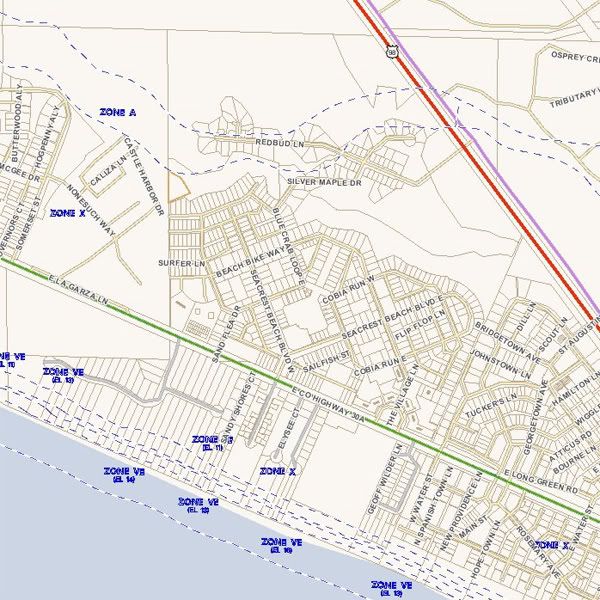
Zone A vs. Zone X through Treetop.
New posts
ASH
Beach Fanatic
I have talked with builders who were aware of wetland and setback concerns in Treetop. I understood that the original survey may have had some errors. My information is secondhand and should not be taken as gospel. Last time I was in there, there were only two homes built, one with great animosity. It's pretty in there though. Great location.
30ashopper
SoWal Insider
I have talked with builders who were aware of wetland and setback concerns in Treetop. I understood that the original survey may have had some errors. My information is secondhand and should not be taken as gospel. Last time I was in there, there were only two homes built, one with great animosity. It's pretty in there though. Great location.
FEMA shows the entire area as a flood zone, right up to the back of Seacrest. Not sure how anyone could "make a mistake" and buy something like that without knowing.


30ashopper
SoWal Insider
Dig a hole back there 3 feet deep before you buy a lot.
Does anyone know what the natural elevation numbers are in reference to NGVD or sea level? Maybe it's well above sea level and just occuring on hard pan.
Seacrest is in good shape - from 30 to 35 feet, Treetop ranges from 12 to about 20 depending on the location.
Smiling JOe
SoWal Expert
One of the two homes built in TreeTops is on a concrete slab.
Smiling JOe
SoWal Expert
FEMA shows the entire area as a flood zone, right up to the back of Seacrest. Not sure how anyone could "make a mistake" and buy something like that without knowing.
I think you mistakenly think that this "Storm Surge" map above is the same as the Flood Zone map. It is not. According to the GIS maps, most of Treetops is not wetlands, and most of the lots in there are in Flood Zone X, meaning that no flood insurance is required (Though I always recommend buying it). However, there are also some parcels in there that are shown in Flood Zone A.
30ashopper
SoWal Insider
I think you mistakenly think that this "Storm Surge" map above is the same as the Flood Zone map. It is not. According to the GIS maps, most of Treetops is not wetlands, and most of the lots in there are in Flood Zone X, meaning that no flood insurance is required (Though I always recommend buying it). However, there are also some parcels in there that are shown in Flood Zone A.
Actually, it looks to be split about even between the two zones. Personally I would never recommend purchaing anywhere in a storm surge or flood zone, but maybe that's just me being paranoid.
Zone A vs. Zone X through Treetop.