
-
Trouble logging in? Send us a message with your username and/or email address for help.
-
Hello all! We will be performing a website & forum update soon. You may get logged out so now is the time to make sure your email address in your account is correct - go to your account to check it and update it now. Send us a message with your username and/or email address if you need help.
You are using an out of date browser. It may not display this or other websites correctly.
You should upgrade or use an alternative browser.
You should upgrade or use an alternative browser.
New big blue signs in SoWal
- Thread starter shesgottasurf
- Start date
New posts


New posts

Beach Runner
beats on hood
Re: What are these things beside the road?
Thanks for the pix.
What the heck? Those are so ugly!Here are some photos... These were taken just west of Sanctuary at Red Fish on 30A. You can see the current Blue Mountain Beach sign in the last photo.
Vicki
Thanks for the pix.
scooterbug44
SoWal Expert
Re: What are these things beside the road?
There was consistent signage (at least IMO), and the wood signs had some charm.
Why exactly did we need the new ones? If people were getting lost or were confused about their location, my suggestion would be better directions, maps, or street signs, not these gaudy blue markers.
My parents have only visited Sowal a total of 2x, yet know exactly where anything is that I am talking about on the phone via the easy landmarks of Alys Beach, Gulf Place, Seaside, and the flashing red lights at 395 and Grayton. :roll:
There was consistent signage (at least IMO), and the wood signs had some charm.
Why exactly did we need the new ones?
If people were getting lost or were confused about their location, my suggestion would be better directions, maps, or street signs, not these gaudy blue markers.My parents have only visited Sowal a total of 2x, yet know exactly where anything is that I am talking about on the phone via the easy landmarks of Alys Beach, Gulf Place, Seaside, and the flashing red lights at 395 and Grayton. :roll:

2bohemians
Beach Fanatic
Re: What are these things beside the road?
In our opinion, these signs are ridiculous. What was wrong with the signs that were already in place. They went with the whole charm of our beaches ... they blended and were soothing to the eyes. These new signs are giant and blue .... waaaaahhhh ... we want the old signs back. How can we get the oldies back?
In our opinion, these signs are ridiculous. What was wrong with the signs that were already in place. They went with the whole charm of our beaches ... they blended and were soothing to the eyes. These new signs are giant and blue .... waaaaahhhh ... we want the old signs back. How can we get the oldies back?
scooterbug44
SoWal Expert
Re: What are these things beside the road?
Good thing we paid a "local" company more because they knew the area :roll:.
They are popping up pretty quick headed east. The interesting thing is that it seems to be redefining parts of 30A already. For instance the Preserve at Grayton is no longer in Grayton and is currently located in Blue Mountain.
Good thing we paid a "local" company more because they knew the area :roll:.
30abob
Beach Lover
Re: What are these things beside the road?

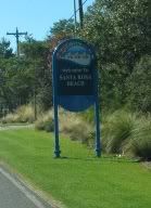
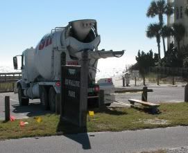
The first shot of the completed sign is across from the west entrance to Draper Lake. The second is at Ed Walline Park, they had just finished pouring the concrete for the bases. (I think the underground portion will definitely hold up in a Hurricane) I'm sorry these aren't better, I was driving at the time.
The first shot of the completed sign is across from the west entrance to Draper Lake. The second is at Ed Walline Park, they had just finished pouring the concrete for the bases. (I think the underground portion will definitely hold up in a Hurricane) I'm sorry these aren't better, I was driving at the time.
Last edited:
Smiling JOe
SoWal Expert
Re: What are these things beside the road?
They are to provide continuity to the varied communities along 30A. (Strange, b/c I thought the people supposedly liked the "uniqueness" of the different developments.)Why exactly did we need the new ones?
The name for the Preserve at Grayton has always been a weird one in my opinion because it is located in what I call Blue Mtn Beach.They are popping up pretty quick headed east. The interesting thing is that it seems to be redefining parts of 30A already. For instance the Preserve at Grayton is no longer in Grayton and is currently located in Blue Mountain.
2bohemians
Beach Fanatic
Re: What are these things beside the road?
Didn't the old / previous signs already have continuity? Weren't they all the same design?
Didn't the old / previous signs already have continuity? Weren't they all the same design?