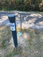
Will B Moderator Nov 23, 2025 #1 This was not here a month ago and has popped up on the bike path west of Aligator Lake. Anyone have any ideas what it is? Attachments IMG_4052.jpg 612.6 KB · Views: 172
This was not here a month ago and has popped up on the bike path west of Aligator Lake. Anyone have any ideas what it is?
Will B Moderator Dec 1, 2025 #3 Kurt said: There's a QR code and phone number on it for more info. Click to expand... I didn't take the picture!
Kurt said: There's a QR code and phone number on it for more info. Click to expand... I didn't take the picture!
Professor Beach Lover Dec 7, 2025 #4 In short, it's a MULTI data collection unit. It's so that FDOT can see what mode of transportation is used on the multi-use path. And how many of whatever mode. If you want more information that you ever could dream of on this system, here ya go: https://path.fdot.gov/Resources/333d37cf-03d3-400d-ba47-9eaed2ebecc6.pdf
In short, it's a MULTI data collection unit. It's so that FDOT can see what mode of transportation is used on the multi-use path. And how many of whatever mode. If you want more information that you ever could dream of on this system, here ya go: https://path.fdot.gov/Resources/333d37cf-03d3-400d-ba47-9eaed2ebecc6.pdf