• Trouble logging in? Send us a message with your username and/or email address for help.
  • Hello all! We will be performing a website & forum update soon. You may get logged out so now is the time to make sure your email address in your account is correct - go to your account to check it and update it now. Send us a message with your username and/or email address if you need help.

Tropical Storm Fay

New posts
If it's the same blob as Invest 92 that's down by Puerto Rico right now, then almost all the reputable models say it's going to recurve through the Bahamas.
 
If it's the same blob as Invest 92 that's down by Puerto Rico right now, then almost all the reputable models say it's going to recurve through the Bahamas.

I can't find any evidence that there is a tropical storm named Faye. All I see if invest 92 and the possibility of becoming a tropical depression.

Where is this tropical storm Faye?
 
at200892_model.gif


From the blog of Dr Masters
www.weatherunderground.com
JeffMasters, 4:50 PM EDT on August 14, 2008

The forecast for 92L
Dry air will probably not be a problem for 92L any more. Wind shear is also not likely to be a problem--shear is forecast to remain below 10 knots the next five days, and may drop to near zero on Friday. Furthermore, an upper-level anticyclone is setting up on top of 92L. This will allow the air lifted from the surface by the storm's heavy thunderstorms to be efficiently spewed out to the sides, ventilating the storm and promoting even more intense thunderstorm activity.

I give 92L a high (>80% chance) of becoming a tropical storm by Friday afternoon. The latest (8 am EDT) model runs all foresee a track for 92L very close to Puerto Rico and the north coast of the Dominican Republic and Haiti Friday through Sunday. Heavy rains will be the main threat to these places, with 4-8 inches likely. Isolated higher amounts of up to 12 inches may fall in the mountains, triggering life-threatening flash floods and mudslides.

In the longer term, an encounter with the rugged terrain of eastern Cuba is forecast by most of the models for Sunday. Passage over the rough terrain of Hispaniola and Cuba could severely disrupt or even destroy 92L. If the storm survives, it could intensify quickly into a hurricane, possibly a major hurricane, once it emerges over the warm waters of the Bahamas or Florida Straits. The eventual strength is highly dependent on the track of 92L, with a longer track over water giving it a greater chance of becoming a hurricane. The long range track of 92L is highly uncertain. Take your pick of 8 am EDT model runs:

GFDL, HWRF: parallel to the east coast of Florida, 50-100 miles offshore
UKMET: Through South Florida into the Gulf of Mexico
NOGAPS: Through the Florida Keys, then northwest towards the Alabama/Mississippi coast
GFS: Through the Bahamas, then north towards North Carolina
Canadian: Across Cuba and through the Cayman Islands, then north in the Gulf of Mexico


Links to follow
Puerto Rico radar
href=http://www.wunderground.com/wundermap/?lat=18.12000084&lon=-65.77999878&zoom=7 target="_blank" >Wundermap for Puerto Rico
St. Thomas, Virgin Islands weather
St. Martin webcam
Puerto Rico weather

Elsewhere in the tropics
A tropical wave (93L) about 1000 miles east of the Lesser Antilles Islands is disorganized, and should not develop during the next 1-3 days. Several of the reliable computer models forecast development of a new tropical wave coming off the coast of Africa about 2-4 days from now.

I'll have an update when NHC designates 92L a tropical depression or tropical storm.

Jeff Masters
 
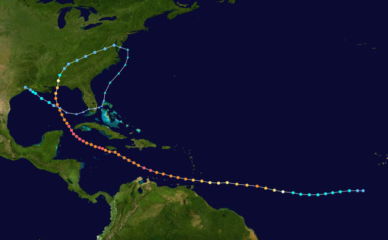
I was just reminiscing about when Ivan came to see us. Look at the weird path it took.

800px-Ivan_2004_track.png
 
Latest guesstimate is east coast (lucky me :shock:) so I hope BobbyJ and others are getting their surfboards ready.
 
Where did you read that, beachSiO2? Six of the eight models, are showing paths pointing towards the Gulf. Notice the latest jogs back to the west for four of the models which at one time were showing a north progression up the east coast.
 
Where did you read that, beachSiO2? Six of the eight models, are showing paths pointing towards the Gulf. Notice the latest jogs back to the west for four of the models which at one time were showing a north progression up the east coast.

I know people who know people ;-). Unfortunately it is not a site I can link to but here were their comments from earlier today. To be fair though, they are not very confident, which is why I called it a "guesstimate." They are hedging their bets that it still to close to call. Also, they use 21 different models.

"We think that the disturbance will track generally westward over Hispaniola this afternoon through Saturday morning. Then, we expect it to move over Cuba on Saturday night and track west-northwestward over the island through Sunday afternoon. Most of our model guidance suggests that the system will make a relatively sharp turn to the north-northwest on Sunday night and track over the western Bahamas on Monday. On Tuesday, our forecast takes the system parallel to the east coast of Florida. At this point, we cannot tell just how close to the east coast of Florida the system will pass. It is quite possible that it may move inland over southeast Florida late Monday or on Tuesday morning. Our best estimate today is that it may pass between 50 and 150 miles east of the Peninsula Monday night and Tuesday. We think that the north-northwesterly track would continue through Wednesday. The system has the potential to move inland into Georgia by the middle of next week."
 
New posts


Sign Up for SoWal Newsletter


Back
Top